
Sepik Soiree
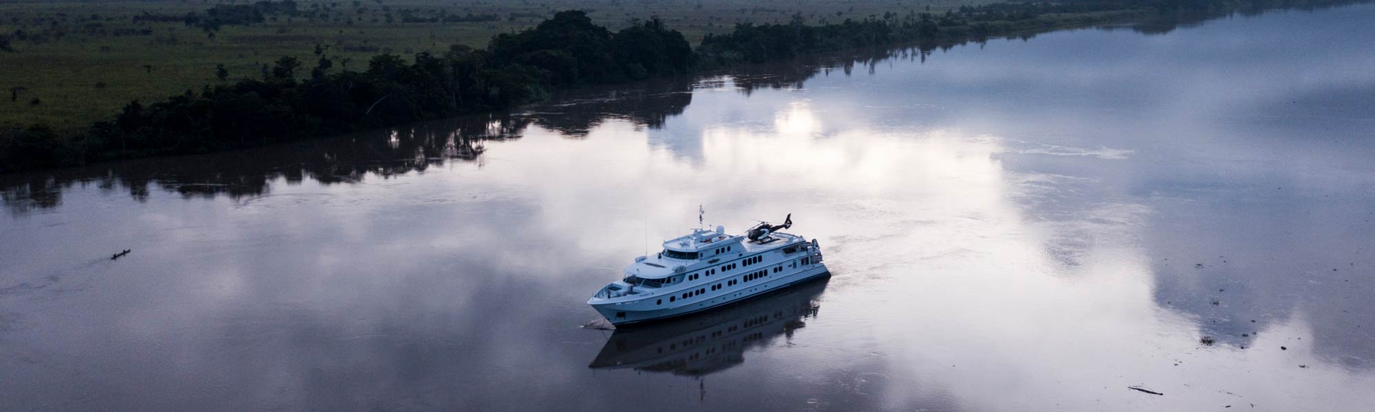
Ship: TRUE NORTH
DEPARTURES: OCT, NOV
From: AU$23,995
STYLE: LUXURY/EXPEDITION
Days: 11
Country: PAPUA NEW GUINEA
Explore the mysterious Sepik River. Witness the infamous crocodile initiation ceremony and visit the stilt houses on Lake Kambaraumba. Wander idyllic tropical isles fringed with sandy beaches and bounded by endless coral reef. Discover Papua New Guinea’s distinctive landscapes – both above and below the water.

ITINERARY SUMMARY

DAY 1 CHARTER FLIGHT CAIRNS TO KAVIENG

To ensure comfort and reliability of service your adventure will begin with a charter flight from Cairns. Our attentive crew members will collect you from your accommodation and escort you on the short flight to Kavieng. As soon as you step off the plane you will begin to reshape your impressions of the “land of the unexpected”. Perhaps the clean and fresh sea breezes will take you by surprise, or will it be the huge smiles of locals so eager to welcome you to their island paradise. After clearing customs, we will transfer you to the on- board luxury of the True North and, the delights of our renowned galley. Enjoy a welcome aboard lunch before we visit a local island resort.
DAY 2 KAVIENG & NEW HANOVER

The many islands around Kavieng and New Hanover are a cruise highlight. A morning sing sing will be a memorable event as every man, woman and child turns out in welcome. Off the beach we find ships, planes and even submarines wrecked in shallow water and beyond the reef it’s time to encounter a marauder of another kind! And, what a place for diving and snorkeling.
DAY 3 BISMARCK ARCHIPELAGO

The Vitu Islands are a volcanic group with an area of 96 km2 located in the Bismarck Archipelago. Formerly called the French Islands, the group is also sometimes known as the Witu Islands. The islands are volcanic ocean peaks and although they are reef-ringed, they are not atolls and therefore highly fertile. The group is the chief copra centre of Papua New Guinea, although the main crop harvested is now cocoa. Garove [or Big Witu] and Unea [Bali] are the largest islands.
Narage Island is a post-eruption volcanic remnant measuring just 210,000 m2. Narage is now shrouded in forest but not far from the shoreline there is a pool of boiling water, providing evidence of more recent volcanic history.
When the Germans were expulsed post World War I the island group was acquired by the trading group Burns Philp. Langu Plantation was ceded by Burns Philp to the Coote family after World War II as compensation following the execution of their family head (and Burns Philp store manager) by the Japanese after he refused to give the invaders keys to Burns Philp’s facilities in Rabaul. The helicopter will provide a bird’s eye view of the entire island group whilst the ship’s expedition boats will deliver guests ashore for historical and cultural tours.
Vitu’s remote coral reefs remain largely unexplored. Few divers have visited this area and many reefs remain un-dived. The visibility is usually superb and pelagic fishes are abundant. Grey reef sharks, silvertip sharks, dog-tooth tuna, rainbow runners and barracuda are seen on most dives. The fish assemblages on these reefs are distinctly oceanic in composition and a number of species that are rare closer inshore are very abundant here.
“Krakafat” is a dive site of particular note – a sea of schooling barracuda, dog tooth tuna, trevally and everything in between. Other sites worthy of exploration include “Dickies Nob”, “Barneys” and the “Arches” at nearby Ningau Island.
DAY 4 MANUS PROVINCE

This morning we wake in Manus Province – very few travellers make it to this remote part of Papua New Guinea. The province consists of several island groups including the Horno Islands, the Admiralty Islands (including Manus Island), the Hermit Islands, Ninigo Islands and Wuvulu Island. The combined land area of the province is just 2,100 square kilometres however 220,000 square kilometres of sparkling sea surrounds. The name Manus is a traditional name for a group of fishing people who inhabit the coastal areas of Manus Island. The name differentiates them from other groups with differing customs and languages.
The outstanding feature of their society was individualism and self-reliance. The most cohesive unit was the clan; a number of clans would make up a village, but they retained their separate identities with-in the village. Each clan would have a men’s house which was built by the most powerful person in the clan. Around this would be a number of family houses. Each house was under the protection of a recently deceased male relative whose skull was kept within the house. The spirit of the deceased was potent for as long as good fortune visited the person who gave the skull shelter. The skull was discarded when the spirit was no longer effective.
The area is renowned for scuba diving and features colourful marine life, coral reefs, shipwrecks, and clear water. During the morning we visit the island of Rambutyo – the second largest island (after Manus) in the Admiralty Islands. The island lies 40 kilometres to the southeast of Manus and here we hope to encounter traditional garamut (split drum) dancers. There will also be opportunity for some short walks and, spectacular helicopter flights over the island group.
In the afternoon we will move to the northern end of Rambutyo – the fringing reefs here are amongst some of the most spectacular we see anywhere in PNG with very high coral cover and spectacular walls dropping into deep water. The mosaic of small islands in the area offers a wonderful backdrop and provides a wide range of different habitats to explore. Oceanic currents move gently through the passes allowing us a free ride as we observe the amazing biodiversity of these marine communities.
Sailfish are also caught in the surrounding waters.
DAY 5 PONAM ISLAND

An entire day devoted to beautiful Ponam Island. The island was occupied by Japanese forces in 1942 and retaken by Allied forces in 1944. American “Seabees” immediately constructed an airfield which was then handed over to the British Royal Navy. The British named the airfield HMS Nabaron. It was not uncommon for damaged aircraft to crash when attempting to land and today the wreckage of several planes can be found in the surrounding waters. Of particular interest is Ensign Jensen’s plane. The naval flyer was the only pilot to report a full-strength Japanese convoy that would have otherwise remained undetected. Unfortunately he was later killed when his plane crashed during a take-off from Ponam and the wreckage can be seen in a lagoon on the east side of the island. The terrestrial remnants of HMS Nabaron should attract the attention of our shore parties whilst the snorkellers will be keen to explore the plentiful bommies and coral outcrops found inside the Manus Barrier Reef. Coral cover is high and brightly coloured butterflyfish and parrotfish are common.
Game fishing for marlin, yellow fin tuna, trevally and mackerel is possible and bottom fishing can produce quality catches of snapper. Ponam is adjacent to the longest coral reef in Manus Province providing plenty of opportunity for SCUBA diving.
The ship’s helicopter* will again swing into action offering a unique prospective of the island’s many lagoons and, nearby Manus Island. There may even be time for a romantic stroll along your very own beach complete with coconut palms and a shimmering South Pacific sunset.
*Please Note: Helicopter excursions are not included in the voyage price. Most days will include an optional helicopter trip, of course weather permitting.
DAY 6 HERMIT ISLANDS

The Hermit Islands form a 22 kilometre long barrier reef: highly rated by the underwater explorer Jean-Michel Cousteau . They are renowned for their clam gardens and the snorkelling is truly spectacular. The gently sloping reef edge disappears into the blue depths with visibility usually exceeding 40 metres, allowing us excellent views of the marine life that inhabits the reef edge. Sharks, manta rays, turtles and large schools of barracuda and trevally all reside here along with the usual array of colourful reef fishes and invertebrates. For the divers – The Hermits also feature incredible reef formations where large schools of mobula rays, snapper, trevally and grey reef sharks are encountered! Fresh ocean currents also make for rip-roaring dives in channels chocked with giant sea fans and soft coral formations.
Marlin and sailfish are also known to occur and hopefully the hikers will catch a glimpse of deer introduced by German colonists. In the afternoon the expedition boats will land at Luf Island – the only inhabited island in the Hermits. Join the crew as we meet the locals and experience local village life.
DAY 7 NINIGO ISLANDS

The Ninigo Islands are a large open-atoll structure surrounded by several smaller atoll formations. In total there are 7 atolls with around 50 small islets – offering great opportunity for exploration.
The largest component of islands forms a 34 km long by 18 km wide atoll that is open on its western side. The major island within the group is Mal, located at the southern end of the outer reef. Other islands on the reef include: Hepi, Lau, Pelipa, Ahu, Sawapil, Chauch, Menan, Longan, Nahanu, Hepisasa, Chacheon, Maichuch, Potaminam, Amik, Puol, Pisa, Ngi, Onia, Wahangahun, Sabucho, Pihun, Keholl, Kamochin, Sand and Nunu. Within the lagoon are the islands of Pingilap, Talil, Hottom, Bahanat and Amot.
The diving here is some of the best encountered in Papua New Guinea. We will endeavour to explore as many of these picture-perfect islands as we can and it’s likely that the day will be filled with magical snorkelling and diving experiences, leviathan struggles with rod and reel, exhilarating dips in the crystal clear lagoons and romantic strolls along the ever-present palm fringed beaches.
DAY 8 & 9 SEPIK RIVER


The Sepik – as far as adventure is concerned, it doesn’t get much better. The Sepik River is the longest river in Papua New Guinea and, one of the great river systems of the world. It has a large catchment area and supports numerous landforms including swamplands, tropical rainforests and mountains. Biologically, the river system is possibly the largest uncontaminated freshwater wetland system in the Asia-Pacific region.
The river’s total length is 1,126 kilometres and it has a drainage basin of over 80,000 square kilometres! There is a 5-10 kilometer wide belt of active meanders along most of the river’s course and a floodplain up to 70 kilometers wide includes extensive backwater swamps. However, unlike many other large river systems, the Sepik has no delta – it flows straight into the sea. The entire Sepik basin remains a largely undisturbed environment – there are no major urban settlements or mining and forestry activities in the river catchment.
Local villagers have lived along the river for many millennia and the river has formed the basis for food, transport and culture. European contact with the river started in just 1885 when German colonists first explored the area. In 1886 and 1887, further expeditions by steam boat were conducted by the Germans and over 600 kilometers of riverine was explored. Between 1912 and 1913 the Germans sent further expeditions to explore the river and surrounding areas. They collected flora and fauna, studied local tribes and produced the first maps. The station town of Angoram was established as a base on the lower Sepik for explorations.
The Sepik is revered for its art. The tribes living along the river produce magnificent wood carvings and artful clay pottery. Many tribes use garamut drums in rituals; the drums are formed from long, hollowed out tree trunks carved into the shape of various totem animals. As part of an elaborate coming of age ceremony, young men are scarified with the image of a crocodile on the river bank.
The True North will arrive at the mouth of the Sepik at first light before proceeding on a 70 nautical mile Sepik River cruise. Then it’s away in the adventure boats and the helicopter for days filled with exploration and discovery.
Witness an elaborate coming of age ceremony where young men are scarified in the image of the crocodile. Other highlights include the township of Angoram – here the waterside market presents as a fantastic opportunity to purchase local carvings. At Kambaraumba village we will be greeted by a sing sing featuring giant crocodile puppets that gyrate through crowds of dancers and drummers – truly a feast for the senses! We also explore the maze of swamps and small waterways that lead to Lake Kambaraumba and its stilt village – a community of huts, churches, schools and animal enclosures built above the waters of the lake.
DAY 10 BAGABAG ISLAND

Bagabag Island is a white-sand island offering excellent fishing, snorkelling, and diving. In the morning the expedition boats will survey the outer-reef which is teeming with fish, turtles and dolphins. The area is also renowned for its endless walls of sea fans, pristine corals and large pelagic species. The inshore coral will entertain the snorkellers and there will also be relaxed opportunities for swimming and beachcombing on a Bagabag beach.
The ship’s helicopter will also be away again – to explore the sounding area and nearby KarKar Island. Karkar is a larger oval-shaped volcanic island about 25 km in length and 19 km in width. In the centre of the island there is an active volcano with two nested calderas. The latest eruptions on this island occurred in the 1970s. The island has a relatively large population of approximately 50,000. The two main exports from the island are cacao and coconuts, which can grow in the same soil due to height differences. The large plantations are generally family owned.
After lunch we’ll go ashore to meet the Bagabag islanders – there are just 4 villages here and apparently the locals are keen to introduce visitors to their unique culture and way of life. The island is rich in betel-nut, local pigs and other food. Life on the island can be quite interesting as there are very few people and they all know each other very well. Then, you will not be able to resist the charms of Christmas Bay – here we can position the True North within 10 metres of the beach – all ashore for sunset drinks before a farewell dinner to remember.
DAY 11 MADANG/CAIRNS

This morning we are alongside in Madang. Transfer to your charter plane and the return flight to Cairns.